M A P S |
Being a work-in-progress website, I've completed about 80% of my travel writing. Available trip details run clockwise with the direction of my trip, from Portland, Oregon to Denver, Colorado. The remaining 20% (Colorado, Utah, Nevada, Arizona, California, and back to Oregon) has yet to be completed.
Click on the map to navigate to my trip's details.
M A P S G U I D E
The website's mapping function provides an easy way for you to navigate the site and serves as a visual "one-stop-shop" for all information pertaining to my trip activities. After selecting a state of interest (ie, Wyoming) you will be presented with color-coded points of interest (ie, hiking in Yellowstone WY) that are clickable. Once clicked, you will whisked off the my write-up pertaining to the selected point of interest.
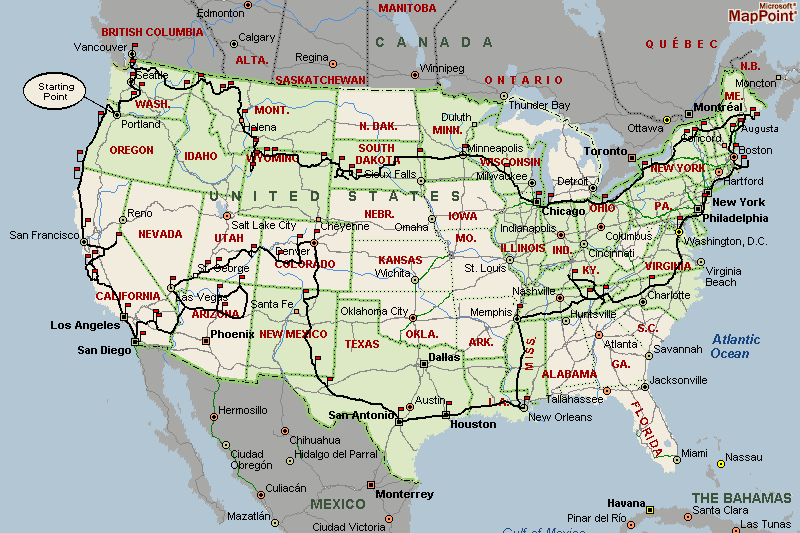
U N I T E D S T A T E S M A P
At the highest level is a map of the United States. At this level you get a 30,000 feet view of my trip route, from start to finish. All visited states where my travel writing has been completed are colored in green and every overnight stay is designated with the little red flag that's stickpinned into my route.
Interested in seeing more detailed information about my goings-on within a particular state? Well, all you have to do is click on the state of interest, and the website will produce a detailed map of the selected state.
Give it a try!
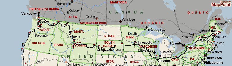
Figure 1.1
Figure 1.1 illustrates my route across the northern section of the country. It consists of many stops with concentrations of stops found at interesting sights (ie, Yellowstone in Wyoming). The route is fairly accurate, however it was drawn free-hand so some minor errors may or may not exist.
S T A T E M A P S
From the United States map you can click on any state to get a detailed map of that state. At the state map level you'll find my trip's path highlighted in black and sprinkled with various flags designating various activities as well as my overnight stays. Clicking on any of the activity flags will display information pertaining only to that activity. Clicking on a pink camping flag will provide easy access to the sum total of the day's activities and events in detail.
At the state map level you can access adjacent states by clicking on them, so there is no need to go back to the map of the United States to pick any state adjacent to the state you are currently viewing.
The map below has been "activated" so you can test navigate to any one of my venues in and around Wyoming.
Give it a whirl!
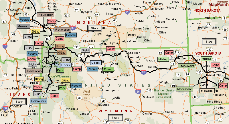
Figure 1.2
Figure 1.2 illustrates my travels through Montana, Wyoming, and South Dakota.
|
MyBigAdventure - Your outdoor adventure travel website for sightseeing, biking, hiking, skiing, snowshoeing, parks, forests, monuments, memorials, landmarks, communities, and much, much more!
Here's a sample of what's inside:
|